Regional Climate Modelling
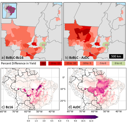 Percent difference in maize yields between (a) Brazil before land clearing (BzBLC) scenarios and Brazil 2016 land cover (Bz16) and (b) BzBLC and the Amazon in all double-cropping rotations (AzDC) across microregions of our study area – highlighted in the pink box in the inset. Average increase in the number of hot (> 35°C) days over the maize growing season (Jan – Aug) for the c) Bz16 scenarios and d) AzDC scenario as compared to the BzBLC scenario.
Land-Use Change, Climate, and Crop Yields
Building off our regional climate modelling work described below, we used the Weather Research and Forecasting model to run 15-year climate simulations across Brazil with with six land-cover scenarios: 1) before extensive land clearing; 2) observed in 2016; 3) Cerrado replaced with single-cropped (soy) agriculture; 4) Cerrado replaced with double-cropped (soy-maize) agriculture; 5) eastern Amazon replaced with single-cropped agriculture; and 6) eastern Amazon replaced with double-cropped agriculture. All land-clearing scenarios (2-6) contain significantly more growing season days with temperatures that exceed critical temperature thresholds for maize. Evaporative fraction significantly decreases across all land-clearing scenarios. Altered weather reduces maize yields between 6–8%, when compared to the before extensive land clearing scenario; however, soy yields were not significantly affected. Our finding provide evidence that land clearing has degraded weather in the Brazilian Cerrado, undermining one of the main reasons for land clearing: rainfed crop production. You can read more about that work here.
Building off our regional climate modelling work described below, we used the Weather Research and Forecasting model to run 15-year climate simulations across Brazil with with six land-cover scenarios: 1) before extensive land clearing; 2) observed in 2016; 3) Cerrado replaced with single-cropped (soy) agriculture; 4) Cerrado replaced with double-cropped (soy-maize) agriculture; 5) eastern Amazon replaced with single-cropped agriculture; and 6) eastern Amazon replaced with double-cropped agriculture. All land-clearing scenarios (2-6) contain significantly more growing season days with temperatures that exceed critical temperature thresholds for maize. Evaporative fraction significantly decreases across all land-clearing scenarios. Altered weather reduces maize yields between 6–8%, when compared to the before extensive land clearing scenario; however, soy yields were not significantly affected. Our finding provide evidence that land clearing has degraded weather in the Brazilian Cerrado, undermining one of the main reasons for land clearing: rainfed crop production. You can read more about that work here.
Modelling Regional Climate across the Cerrado
We can use the satellite data to monitor and analyze changes in environmental factors, such as forest cover or evapotranspiration, but observations alone cannot be used to discern the physical mechanisms and causal relationships that result in environmental changes. Land-cover-climate feedbacks can be better investigated by integrating spatial datasets and analyses with models. I used NCAR's regional climate model, the Weather Research and Forecasting (WRF) model, to investigate the physical relationships between land-cover change and regional climate in the Cerrado, and determine how best to maximize agricultural production and minimize negative climatic environmental consequences, specifically, limiting deforestation and land-cover-change-induced modifications in precipitation and temperature.
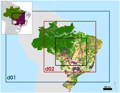
The first step to assessing these impacts is determining whether a more accurate land surface improves simulation results and where the model still needs to be improved. I use WRF to run 10‐year‐long climate simulations across Brazil with both the default U.S. Geological Survey land cover map and an updated land cover map with two new agricultural categories. Our results show that using an updated map improves model results over regions of intensive agriculture, especially in the dry‐to‐wet‐season transition months. All simulation results show an overestimation in evapotranspiration rates and a cold bias during the rainy season. These biases seem to be the result of WRF's soil‐moisture model. Understanding both these interactions and how we can use climate models to better study them is essential for making informed land use decisions. Click here to read more about this work.
We can use the satellite data to monitor and analyze changes in environmental factors, such as forest cover or evapotranspiration, but observations alone cannot be used to discern the physical mechanisms and causal relationships that result in environmental changes. Land-cover-climate feedbacks can be better investigated by integrating spatial datasets and analyses with models. I used NCAR's regional climate model, the Weather Research and Forecasting (WRF) model, to investigate the physical relationships between land-cover change and regional climate in the Cerrado, and determine how best to maximize agricultural production and minimize negative climatic environmental consequences, specifically, limiting deforestation and land-cover-change-induced modifications in precipitation and temperature.
The first step to assessing these impacts is determining whether a more accurate land surface improves simulation results and where the model still needs to be improved. I use WRF to run 10‐year‐long climate simulations across Brazil with both the default U.S. Geological Survey land cover map and an updated land cover map with two new agricultural categories. Our results show that using an updated map improves model results over regions of intensive agriculture, especially in the dry‐to‐wet‐season transition months. All simulation results show an overestimation in evapotranspiration rates and a cold bias during the rainy season. These biases seem to be the result of WRF's soil‐moisture model. Understanding both these interactions and how we can use climate models to better study them is essential for making informed land use decisions. Click here to read more about this work.