AGRICULTURAL LAND SCARCITY IN MATO GROSSO, BRAZIL.
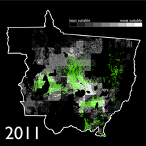
During the first half of the 2000s, Mato Grosso was home to agricultural expansion and high deforestation rates. However, during the the latter half of the decade, deforestation rates decreased while intensification of agriculture – the planting of two crops, often a soy/corn rotation, during one growing season increased nearly 6-fold. Some attribute this coupled deforestation decrease-intensification increase to the 2006 soy moratorium, but I posit that it may also be related to land scarcity within Mato Grosso (image on the left shows agricultural areas in green, the most suitable land for agriculture in white, and the least suitable land in black). Click here to read more about this work.
SUGARCANE PRODUCTION INCREASES 8-FOLD IN GOIAS, BRAZIL.
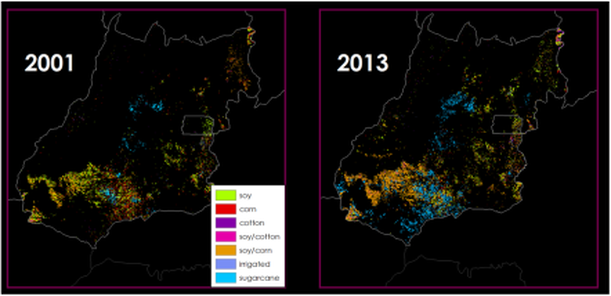
Between 2003 and 2013, Goias State (below) went from Brazil's seventh largest producer of sugarcane to its third. Now it is second only to the state of Sao Paulo. During this time, sugarcane area (blue on maps) expanded over six-fold, to 847,000 ha in 2013. By integrating remote sensing, GIS, and spatial statistical analyses, we determined that pasture was seven times more likely to be converted to sugarcane than soy; capital, infrastructure and institutions constrain sugarcane production; and areas were soy is currently cultivated may be converted to sugarcane in the future given the planned expansion of transportation and sugarcane infrastructure. We conclude by suggesting sugarcane be cultivated on on degraded pastures and increasing pasture stocking rates to ensure continued protection of both natural vegetation and food production while supporting sugarcane expansion in the state. Click here to read more about this work.